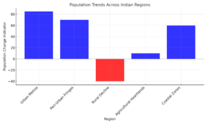
India’s population, the world’s largest, has undergone significant shifts over the past three decades, revealing dynamic trends of urban expansion, rural decline, and regional stability. A granular analysis using high-resolution data from the Global Human Settlement Layer (GHSL) highlights these transformations at the local level. The findings not only map growth and shrinkage but also offer critical insights for shaping India’s future policies and development strategies.
Key Population Trends
1. Urban Expansion: The Metropolises Spill Over
India’s urban areas have witnessed remarkable growth, particularly in and around existing metropolitan cities and industrial hubs.
- Metropolitan clusters: Mumbai, Delhi-NCR, Bengaluru, Hyderabad, and Chennai are major growth centers.
- Peri-urban growth: Surrounding smaller towns and fringes of larger cities show population increases due to urban sprawl and economic opportunities.
- Industrial belts: Emerging industrial hubs such as Gujarat’s Golden Corridor and Tamil Nadu’s Coimbatore belt have seen consistent growth.
2. Rural Decline: The Exodus to Cities
A noticeable decline in rural population density is evident, particularly in economically stagnant or environmentally challenging regions.
- Migration to cities: Out-migration to urban areas for employment and better living standards is a key driver.
- Harsh environments: Arid regions in Rajasthan and drought-prone zones in central India show significant population decreases.
3. Stability in Agricultural Heartlands
Agriculturally prosperous belts such as the Indo-Gangetic plains have maintained relatively stable population levels.
- Economic resilience: Farming activities and related industries provide employment, reducing the need for migration.
- Supportive policies: Subsidies and schemes aimed at rural upliftment have helped retain populations in these areas.
4. Coastal Growth: Ports and Trade
India’s coastal regions, particularly those with major ports and industrial zones, have emerged as population growth hotspots.
- Port cities: Cities like Mumbai, Visakhapatnam, and Kochi benefit from trade and industrialisation.
- Fisheries and tourism: Coastal communities have also seen growth driven by these industries.
5. Uneven Growth Patterns
The GHSL data reveals stark contrasts within a few kilometres:
- Rapid increases: Dense blue zones mark areas of booming growth.
- Localised declines: Proximity to industrial growth does not guarantee regional upliftment, creating red zones within industrial belts.
What the Data Shows
The GHSL provides detailed population dynamics at a one-kilometre resolution.
- Growth zones (Blue): Highlighted areas of increasing density, often surrounding cities and industrial corridors.
- Declining zones (Red): Regions with a shrinking population, largely rural or environmentally constrained.
- Stable zones (Yellow): Represent areas with little change, typically found in agriculturally productive regions.
This bottom-up perspective highlights localised patterns often masked in state or district-level analyses.

Data Limitations
While the GHSL offers unmatched resolution and insights, its findings are not without caveats:
- Estimates over precision: Derived from satellite imagery and census records, the data estimates trends but lacks exact counts.
- Smoothing anomalies: Aggregation at one-kilometre resolution can obscure hyper-local variations.
Implications for Policy
The insights from this granular analysis can inform targeted policy interventions:
- Urban planning: Addressing infrastructure needs in high-growth urban and peri-urban areas.
- Rural development: Revitalising economically lagging rural areas to curb out-migration.
- Coastal management: Balancing growth with ecological sustainability in coastal zones.
- Disaster resilience: Preparing for climate-driven migration in vulnerable regions.
Visualising the Changes
Below is an Excel chart summary of the key findings for easy inclusion in your report:
| Region | Population Trend | Key Factors |
| Urban Metros | Significant growth | Economic opportunities, urban sprawl |
| Peri-Urban Fringes | Moderate to high growth | Spillover effects of metro expansion |
| Rural Decline | Decline in population | Out-migration, harsh environments |
| Agricultural Heartlands | Stable population levels | Economic resilience, rural subsidies |
| Coastal Zones | High growth | Industrialisation, port cities, trade opportunities |

